
No great trail comes into the world fully formed.
The famous Appalachian Trail was first conceived by Benton MacKaye in 1921. The first section opened in 1923 and the original trail was completed in 1937, but it continues to evolve, a hundred years after its conception.
The Great Plains Trail is no different. Steve Myers, founder of the Great Plains Trail Alliance, first conceived and began mapping out a walking and bicycling route from Texas to the Canadian border across the Great Plains more than a decade ago, but it continues to be refined every year, bit by bit.
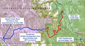
For example, in 2020, the U.S. Forest Service rerouted the trail southeast of Crawford, Nebraska through the state’s Ponderosa Wildlife Management Area, replacing some five miles of dirt road walking with single- and double-track trail through undeveloped areas. The trail now heads west from a public picnic area in West Ash Creek Canyon and traverses federal land and some 2.7 miles of the wildlife management area to Squaw Creek Road.
Mike Watts, resource specialist for the Forest Service, said the general idea for putting a trail through the area predates the GPT. The new section of trail finally came to fruition thanks to legwork and negotiation by both Myers and Watts.
“For a long time we’ve wanted to get something across the Ponderosa (WMA) to Squaw Creek, but there had been some resistance from the state,” to putting a marked trail through an area primarily managed for hunting, Watts says.
But Myers had been talking to the manager of the WMA, who was open to the idea of a trail along the southern boundary of the property, Watts says.
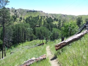
Watts started exploring the area to come up with a workable route. He first mapped the route from West Ash Creek Road to the boundary of the WMA. From there, he plotted some three miles across an area burned in 1985 and 2012 wildfires — mostly along an existing two-track — to the “rim of the world” road atop Squaw Creek Canyon, a total of about 6 miles. A steeper alternate into the canyon via a fire road adds up to about 4.7 miles, Watts says.
“There’s one big canyon we had to figure out how to get a cross without doing all kinds of switchbacks and construction,” he says. “We found something that worked pretty well, though it was still a little bit of a challenge.”
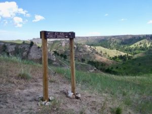
The first several miles of trail, from West Ash Creek Road to the WMA boundary, are well-marked.
“We put in treadwork in a lot of places, on steep sidehills,” Watts says.
However, state game commissioners balked at the idea of a marked trail through the WMA, so GPT travelers will have to exercise some navigation skills once they enter the area.
“It still works well, even unmarked,” Watts says. “We’ve got signs warning people at the trailhead, so that’s good.”
Once on Squaw Creek Road, northbound GPT travelers can reach Crawford via Squaw Log Road, Dyer Road, both dirt, and Nebraska Highway 71, a total distance of 7-7.5 miles.